You can view NBTA London’s September 2022 Position Statement on the “Water Safety Zones” here
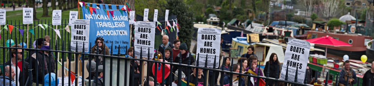
Canal and River Trust (CRT) are trying cull boat numbers.
When CRT first proposed the full details of the Water “Safety” Zones we calculated that 550 mooring spaces would be lost in Broxbourne and Tottenham/Hackney in some places this included no double mooring and no wider boats. Following the magnificent efforts of the boating community to push back against the “Safety” Zones, CRT appeared to desist from their implementation in favour of a navigation forum of stakeholders. But in fact CRT are still attempting to impose perhaps the most draconian part of the original “Safety” Zones – the new no mooring sections. We now estimate that 295 casual mooring opportunities will be lost as a result.
It is these 295 spaces which we are now fighting to protect!
They want more space to row, but where do we go?
The justification offered for the introduction of the ‘safety zone’ is to keep rowers safe. CRT has not provided boaters with any evidence, however, that rowers are placed at risk by powered boats moving at 4mph. It’s claimed that moored boats narrowing the canal pose a danger to rowers, but there is no point on the canal where rowers do not have substantial clearance in the event that a boat passes.
CRT marketed this policy as a ‘water sports’ strategy before re-branding it as a question of ‘safety’. The more likely point of contention is not safety but rather the ordinary inconvenience and frustration that can result from rowers and boaters having to share the water. CRT has translated an elementary management question into a catastrophic policy.
Indeed, despite claiming to address safety concerns, the policy evacuates certain parts of the canal so that fallen-in rowers will have no way of climbing out in the absence of moored boats and boaters to help.
The areas targeted also include two vital boater hubs for toilet and water services. Forcing boats out of these areas means that rowers will encounter increased boat traffic within the ‘safety zone’ as dispersed boats traverse the rowing areas to access services. Once again, the policy defeats its stated aim.
Ironically, other serious safety concerns are ignored. Evacuated parts of the canal will revert to the crime zones that they were before boaters made them safe for all to enjoy. Boaters and members of the public walking the towpath in these areas will once again become victims of muggings and violent crime.
Since the policy is incoherent, boaters are led to question whether a general push to cull the boating community is its driving force and whether ‘safety’ is a convenient fig leaf for ugly bias.
Given London’s housing crisis, boating is often the last line of defense for those who would otherwise be homeless. Many of those who are forced to abandon the boating life will have very few alternatives and some will have none. Is this fair? Does this represent the values that CRT, a charitable trust, claims to uphold?
To save our homes and way of life, boaters want to develop real solutions, rather than scorched-earth solutions. We are working together to develop a fair and just proposal that addresses the concerns of rowers while keeping homes and families on the water. We hope to publish our proposal soon.
We appeal to other communities to help us protect our homes and way of life by opposing CRT’s plan.
If you would like to be involved in stopping CRT plans, email nbtalondon@gmail.com
Email CRT Matthew.symonds@canalrivertrust.org.uk to express your view towards the ‘Safety Zones’.
_________________________________________________________________
_________________________________________________________________
How we got to the number of mooring spaces lost
Assumptions:
Boats are 15m in length on average
Zones are divided by 20m to take account of 5m advisory gap between boats
Red zone calculation excludes bridges and areas where mooring would impede navigation.
LOWER LEE:
Yellow zone is 1939m
Possible moorings in Y zone: (1939/15) x 2 = 258
Actual moorings in Y zone: 1939/20 = 97
Loss: 161
Red zone is 1259m
Possible moorings: (1259/15) x 2 = 168
Actual moorings: 0
Loss: 168
Green zone is 2279m
Possible moorings: (2279/15) x2 = 304
Actual moorings: (2279/20) x2 = 228
Loss: 76
Total loss: 161 + 168 + 76 = 405
This figure excludes approx 38 lost widebeam spots in the green zone, since WB and NB can no longer moor together, if we assume 25% of boats are widebeams.
WB moorings lost in G: (2279/15) x 0.25 = 38
Red zone figure excludes bridges but includes the bendy bit at Clapton, north of Princess of Wales, where people currently moor.
BROXBOURNE:
1800m of moorable area no longer moorable to WB (excludes areas too shallow to moor)
WB:
1800/15 = 120 lost
NB:
Possible moorings: 1800/15= 120
Actual moorings: 1800/20 = 90
Loss: 30
Total loss: 120 + 30 = 150

I do think that this is a surreptitious political move, rather than a ‘safety’ move. I didn’t realise that so many boats would be effected either. We regularly cycle up the River Lea to Broxbourne, and I have to say that we prefer to take the routes where the canal boats are moored. We love seeing them and love to experience the sense of community that they bring to the riverside. Perhaps that’s what the council and the government don’t like (and wealthy house owners). You’re not falling into line with everyone else and ‘paying your way’ so to speak!
LikeLike
Boat dwelling communities in London are a special component of the city’s rich and varied heritage. There is room for both rowers and boat dwellers.
LikeLike